From June 3-5* 2020 the TEUFOR conference will take place in Kraków/ Poland. The topic is “Modern Technologies and Engineering in Sustainable Forest Utilization“. Main objectives of the event are:
“Presenting and discussing current scientific and practical achievements in the field of forest utilization based on forest technique and engineering development in terms of permanent and sustainable forest management.
Exchanging current scientific attainments and practical applications between scientific centres of many countries in Europe and around the world shall contribute to increase quality of forest utilization as well as intensify international cooperation in the scope of conducted research, higher education and international scholar exchange.
The panels will focus on: forest utilization and transportation; ergonomics in forestry; forest technology; and forest engineering.
Stay in touch to keep updated on which TECH4EFFECT results will be presented at TEUFOR!
Forest soils can be disturbed or even damaged by a range of activities, most prominently in the form of soil compaction and soil displacement, frequently resulting in rutting. This may cause massive drawbacks on permanent accessibility to forest stands and a deterioration of future growing potential. Also, tree diseases (such as root rot) could spread faster, with negative impacts on future wood quality and timber revenues. In addition, they affect tree stability making the forest less safe and less attractive to other stakeholders, for instance for recreational users.
Other severe impacts of the degradation of soils are of specific importance for forest contractors: Due to high rutting and wheel slippage, harvesting and the cost of timber extraction is directly negatively influenced by higher fuel consumption and hampered productivity. Recently, TECH4EFFECT partner Georg-August-Universität Göttingen finalized results of their first analyses of trafficability maps resulting in the presentation of their Public Deliverable (D4.1) “Terrain Accessibility for 4 Case Study Areas”.
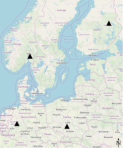
Four study sites in Europe
To keep disturbances of forest soils to a minimum, it is of utmost importance to gain more knowledge on the sensitivity of certain forest areas when planning and conducting harvesting operations with heavy forest machines. Although some trafficability maps are available already, they are not commonly used due to the lack of information on soil bearing capacity and a high level of specificity. TECH4EFFECT partner, the University of Göttingen, describes the principles of handier trafficability maps and shows evaluations of their application at four case study areas.
The four study areas are located in Finland, Germany, Norway and Poland (Fig. 1) with each area approximately 50 km² large. The selected areas cover flat to hilly-mountainous terrain types and their mean annual precipitation ranges from around 660 to 860 mm. The study sites are primarily stocked with coniferous tree species, despite the site in Germany, covered by beech.
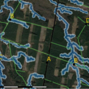
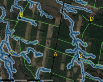
Depth-to-Water-algorithm (DTW) for avoiding soil disturbance
The generated maps rely on the Depth-to-Water algorithm (DTW), which estimates the vertical distance to areas with appearing surface water or water saturated soils (Fig. 2). The main advantage of these mappings is that permanent and perennial stream networks within the forest soils can be detected. This could help forest machine operators identify sensitive areas with regards to trafficability – based on this heavy machinery can be kept out of certain areas with low soil bearing capacity. For direct access of the operators to DTW-maps, all it would take would be an upload of a particular map to the on-board computer of the machine.
One of the principal investigators, Marian Schönauer, says: “To get better knowledge of actual trafficability of skid trails is really important since it has many different, serious affects for forest operations and forest contractors. DTW-maps are a potentially powerful tool for these applications for the future!”
Conclusion
Although these DTW-maps are based on digital
terrain models only, they still have the potential to contribute to the reduction
of rutting during forest operations,
in particular at sensitive sites. Schönauer says: “With the application of the
DTW-maps in forest operations, critical areas in terms of low DTW-index,
permanent and perennial streams can be identified and avoided by forest machine
operators. A sufficient way to facilitate this can be realised by providing the
maps on the on-board computers of forwarders and harvesters. Within TECH4EFFECT
we are also focusing on a conjunction with other data, for example precipitation
data and weather forecasts.” Future work could explore incorporating
additional data sources into the algorithm, such as soil moisture and climatic
conditions to improve the accuracy and informative value of used maps to
predict soil bearing capacity and trafficability of permanent skid trails in
particular.
To read the full text please go to the TECH4EFFECT website and download the deliverable as PDF! If you want to test the maps please contact the University of Göttingen directly at foresteng (a) uni-goettingen.
Acknowledgement
When preparing this deliverable, the University of New Brunswick (Canada), especially Professor Paul Arp from the Department of Forestry and Environmental Management (I.U.C. Forestry 311, Fredericton), kindly contributed time and resources to calculate high resolutions DTW maps.
Contact
Georg-August-Universität Göttingen, DI Marian Schönauer (Dirk Jaeger lab)
If you want to know more about the TECH4EFFECT project please visit our website. For the latest news on precision forestry, forestry management and the sustainable use of natural resources follow us on social media such as Twitter, LinkedIn, YouTube and Research Gate, and consider subscribing to our TECH4EFFECT newsletter!
http://www.tech4effect.eu/wp-content/uploads/2020/03/image-2.png266334TECH4EFFECThttp://www.tech4effect.eu/wp-content/uploads/2016/10/Tech4Effect-logo-transparente-Kreise.pngTECH4EFFECT2020-03-09 13:21:172020-07-08 14:37:14Public deliverable out now! Establishment of terrain accessibility maps for 4 case study areas
We use cookies to ensure that we give you the best experience on our website. We'll assume you're ok with this, but you can opt-out if you wish in your browser settings.
We may request cookies to be set on your device. We use cookies to let us know when you visit our websites, how you interact with us, to enrich your user experience, and to customize your relationship with our website.
Click on the different category headings to find out more. You can also change some of your preferences. Note that blocking some types of cookies may impact your experience on our websites and the services we are able to offer.
Essential Website Cookies
These cookies are strictly necessary to provide you with services available through our website and to use some of its features.
Because these cookies are strictly necessary to deliver the website, refusing them will have impact how our site functions. You always can block or delete cookies by changing your browser settings and force blocking all cookies on this website. But this will always prompt you to accept/refuse cookies when revisiting our site.
We fully respect if you want to refuse cookies but to avoid asking you again and again kindly allow us to store a cookie for that. You are free to opt out any time or opt in for other cookies to get a better experience. If you refuse cookies we will remove all set cookies in our domain.
We provide you with a list of stored cookies on your computer in our domain so you can check what we stored. Due to security reasons we are not able to show or modify cookies from other domains. You can check these in your browser security settings.
Google Analytics Cookies
These cookies collect information that is used either in aggregate form to help us understand how our website is being used or how effective our marketing campaigns are, or to help us customize our website and application for you in order to enhance your experience.
If you do not want that we track your visit to our site you can disable tracking in your browser here:
Other external services
We also use different external services like Google Webfonts, Google Maps, and external Video providers. Since these providers may collect personal data like your IP address we allow you to block them here. Please be aware that this might heavily reduce the functionality and appearance of our site. Changes will take effect once you reload the page.
Google Webfont Settings:
Google Map Settings:
Google reCaptcha Settings:
Vimeo and Youtube video embeds:
Other cookies
The following cookies are also needed - You can choose if you want to allow them:
Privacy Policy
You can read about our cookies and privacy settings in detail on our Privacy Policy Page.